Day 2: by 10/10 (A) & 10/11 (B)
Wegener's theory was rejected by the scientific community, in part because of a prevailing view at that time that the Earth was solid and rigid. Were it not for a small dedicated group of scientists and the emergence of new scientific data and methods, the theory could have been largely forgotten. Fortunately, a new field of scientific study, paleomagnetism, emerged giving proponents of Wegener's theory new hope that they might be able to prove the existence of a super continent.
When some rocks are created, they are magnetized in the direction of the earth's magnetic field. Paleomagnetists, drilling into prehistoric rock, discovered that the Earth's magnetic field, in fact, changes direction every few hundred thousand years. Observations of these alternating regions, found to be symmetrical on both sides of ocean floor ridges, have given scientists strong evidence of a key mechanism for creating continental drift. As new material wells up from the Earth's mantle, the sea floor spreads.
When some rocks are created, they are magnetized in the direction of the earth's magnetic field. Paleomagnetists, drilling into prehistoric rock, discovered that the Earth's magnetic field, in fact, changes direction every few hundred thousand years. Observations of these alternating regions, found to be symmetrical on both sides of ocean floor ridges, have given scientists strong evidence of a key mechanism for creating continental drift. As new material wells up from the Earth's mantle, the sea floor spreads.
However, it was only in the 1960s, when improved seismological instrumentation and other measuring devices were developed, that Wegener's theory was confirmed. In studies funded by the U.S. Navy to improve submarine warfare, researchers began mapping the ocean floor, collecting data to explain the magnetic anomalies that were affecting sonar readings. From this data, scientists confirmed that the sea floor was indeed spreading apart.
In 1985, the Navy launched a satellite called "Geosat" whose goal was to measure variations in gravity on the Earth's surface, which would then submarine commanders - and scientists - where underwater mountains and valleys were located. From 500 miles above the Earth, Geosat used radar to create an incredibly accurate map of the sea floor. Within a few short years, scientists studying this new data found conclusive evidence of continental drift and discovered additional evidence to validate the theory of plate tectonics.
Sea Floor Spreading Theory
In 1961, scientists began to theorize that mid-ocean ridges mark structurally weak zones where the ocean floor was being ripped in two lengthwise along the ridge crest. New magma from deep within the Earth rises easily through these weak zones and eventually erupts along the crest of the ridges to create new oceanic crust. This process, called seafloor spreading, operating over many millions of years has built the 50,000 km-long system of mid-ocean ridges. Harry H. Hess, a Princeton University geologist and a Naval Reserve Rear Admiral, and Robert S. Dietz, a scientist with the U.S. Coast and Geodetic Survey first coined the term seafloor spreading. Dietz and Hess were among the small handful who really understood the broad implications of sea floor spreading. If the Earth's crust was expanding along the oceanic ridges, Hess reasoned, it must be shrinking elsewhere. He suggested that new oceanic crust continuously spread away from the ridges in a conveyor belt-like motion. Many millions of years later, the oceanic crust eventually descends into the oceanic trenches -- very deep, narrow canyons along the rim of the Pacific Ocean basin.
According to Hess, the Atlantic Ocean was expanding while the Pacific Ocean was shrinking. As old oceanic crust was consumed in the trenches, new magma rose and erupted along the spreading ridges to form new crust. In effect, the ocean basins were perpetually being "recycled," with the creation of new crust and the destruction of old oceanic lithosphere occurring simultaneously. Thus, Hess' ideas neatly explained why the Earth does not get bigger with sea floor spreading, why there is so little sediment accumulation on the ocean floor, and why oceanic rocks are much younger than continental rocks.
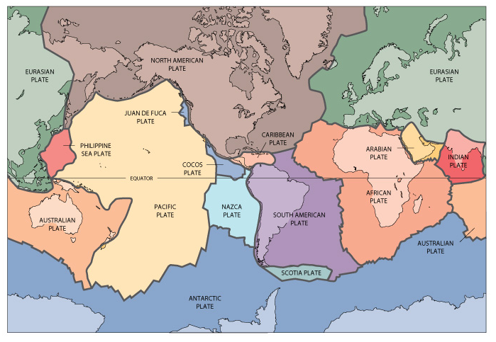
Scientists now understand that the Earth's surface (the upper 45-60 miles of crust) is divided into massive plates which move 1 to 4 inches per year. The margins of where these plates spread, collide, and slide past each other are where earthquakes, volcanoes, and mountains are concentrated.
There are plates of drastically different shapes and sizes that move along the Earth's crust. From the massive Pacific and European plates, to the smaller Caribbean and Juan de Fuca plates, each plate can react differently when coming into contact with another plate.
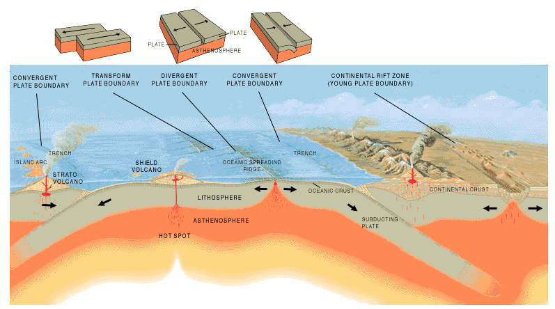
There are three types of plate boundaries:
Divergent boundaries
Divergent boundaries occur along spreading centers where plates are moving apart and new crust is created by magma pushing up from the mantle. Picture two giant conveyor belts, facing each other but slowly moving in opposite directions as they transport newly formed oceanic crust away from the ridge crest.
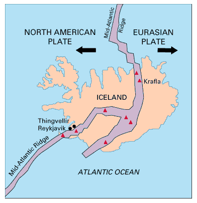
Perhaps the best known of the divergent boundaries is the Mid-Atlantic Ridge. This submerged mountain range, which extends from the Arctic Ocean to beyond the southern tip of Africa, is but one segment of the global mid-ocean ridge system that encircles the Earth. The rate of spreading along the Mid-Atlantic Ridge averages about 2.5 centimeters per year (cm/yr), or 25 km in a million years. This rate may seem slow by human standards, but because this process has been going on for millions of years, it has resulted in plate movement of thousands of kilometers. Seafloor spreading over the past 100 to 200 million years has caused the Atlantic Ocean to grow from a tiny inlet of water between the continents of Europe, Africa, and the Americas into the vast ocean that exists today.
The volcanic country of Iceland, which straddles the Mid-Atlantic Ridge, offers scientists a natural laboratory for studying on land the processes also occurring along the submerged parts of a spreading ridge. Iceland is splitting along the spreading center between the North American and Eurasian Plates, as North America moves westward relative to Eurasia.
In 1985, the Navy launched a satellite called "Geosat" whose goal was to measure variations in gravity on the Earth's surface, which would then submarine commanders - and scientists - where underwater mountains and valleys were located. From 500 miles above the Earth, Geosat used radar to create an incredibly accurate map of the sea floor. Within a few short years, scientists studying this new data found conclusive evidence of continental drift and discovered additional evidence to validate the theory of plate tectonics.
Sea Floor Spreading Theory
In 1961, scientists began to theorize that mid-ocean ridges mark structurally weak zones where the ocean floor was being ripped in two lengthwise along the ridge crest. New magma from deep within the Earth rises easily through these weak zones and eventually erupts along the crest of the ridges to create new oceanic crust. This process, called seafloor spreading, operating over many millions of years has built the 50,000 km-long system of mid-ocean ridges. Harry H. Hess, a Princeton University geologist and a Naval Reserve Rear Admiral, and Robert S. Dietz, a scientist with the U.S. Coast and Geodetic Survey first coined the term seafloor spreading. Dietz and Hess were among the small handful who really understood the broad implications of sea floor spreading. If the Earth's crust was expanding along the oceanic ridges, Hess reasoned, it must be shrinking elsewhere. He suggested that new oceanic crust continuously spread away from the ridges in a conveyor belt-like motion. Many millions of years later, the oceanic crust eventually descends into the oceanic trenches -- very deep, narrow canyons along the rim of the Pacific Ocean basin.
According to Hess, the Atlantic Ocean was expanding while the Pacific Ocean was shrinking. As old oceanic crust was consumed in the trenches, new magma rose and erupted along the spreading ridges to form new crust. In effect, the ocean basins were perpetually being "recycled," with the creation of new crust and the destruction of old oceanic lithosphere occurring simultaneously. Thus, Hess' ideas neatly explained why the Earth does not get bigger with sea floor spreading, why there is so little sediment accumulation on the ocean floor, and why oceanic rocks are much younger than continental rocks.
Scientists now understand that the Earth's surface (the upper 45-60 miles of crust) is divided into massive plates which move 1 to 4 inches per year. The margins of where these plates spread, collide, and slide past each other are where earthquakes, volcanoes, and mountains are concentrated.
There are plates of drastically different shapes and sizes that move along the Earth's crust. From the massive Pacific and European plates, to the smaller Caribbean and Juan de Fuca plates, each plate can react differently when coming into contact with another plate.
There are three types of plate boundaries:
- Divergent boundaries -- where new crust is generated as the plates pull away from each other.
- Convergent boundaries -- where crust is destroyed as one plate dives under another.
- Transform boundaries -- where crust is neither produced nor destroyed as the plates slide horizontally past each other.
Divergent boundaries
Divergent boundaries occur along spreading centers where plates are moving apart and new crust is created by magma pushing up from the mantle. Picture two giant conveyor belts, facing each other but slowly moving in opposite directions as they transport newly formed oceanic crust away from the ridge crest.
Perhaps the best known of the divergent boundaries is the Mid-Atlantic Ridge. This submerged mountain range, which extends from the Arctic Ocean to beyond the southern tip of Africa, is but one segment of the global mid-ocean ridge system that encircles the Earth. The rate of spreading along the Mid-Atlantic Ridge averages about 2.5 centimeters per year (cm/yr), or 25 km in a million years. This rate may seem slow by human standards, but because this process has been going on for millions of years, it has resulted in plate movement of thousands of kilometers. Seafloor spreading over the past 100 to 200 million years has caused the Atlantic Ocean to grow from a tiny inlet of water between the continents of Europe, Africa, and the Americas into the vast ocean that exists today.
The volcanic country of Iceland, which straddles the Mid-Atlantic Ridge, offers scientists a natural laboratory for studying on land the processes also occurring along the submerged parts of a spreading ridge. Iceland is splitting along the spreading center between the North American and Eurasian Plates, as North America moves westward relative to Eurasia.
In East Africa, spreading processes have already torn Saudi Arabia away from the rest of the African continent, forming the Red Sea. The actively splitting African Plate and the Arabian Plate meet in what geologists call a triple junction, where the Red Sea meets the Gulf of Aden. A new spreading center may be developing under Africa along the East African Rift Zone. When the continental crust stretches beyond its limits, tension cracks begin to appear on the Earth's surface. Magma rises and squeezes through the widening cracks, sometimes to erupt and form volcanoes. The rising magma, whether or not it erupts, puts more pressure on the crust to produce additional fractures and, ultimately, the rift zone.
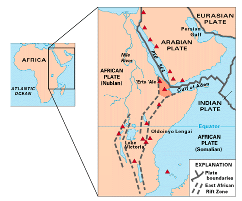
East Africa may be the site of the Earth's next major ocean. Plate interactions in the region provide scientists an opportunity to study first hand how the Atlantic may have begun to form about 200 million years ago. Geologists believe that, if spreading continues, the three plates that meet at the edge of the present-day African continent will separate completely, allowing the Indian Ocean to flood the area and making the easternmost corner of Africa (the Horn of Africa) a large island.
Convergent boundaries
The size of the Earth has not changed significantly during the past 600 million years, and very likely not since shortly after its formation 4.6 billion years ago. The Earth's unchanging size implies that the crust must be destroyed at about the same rate as it is being created, as Harry Hess surmised. Such destruction (recycling) of crust takes place along convergent boundaries where plates are moving toward each other, and sometimes one plate sinks (is subducted) under another. The location where sinking of a plate occurs is called a subduction zone.
The type of convergence -- called by some a very slow "collision" -- that takes place between plates depends on the kind of lithosphere involved. Convergence can occur between an oceanic and a largely continental plate, or between two largely oceanic plates, or between two largely continental plates.
Oceanic-continental convergence
If by magic we could pull a plug and drain the Pacific Ocean, we would see a most amazing sight -- a number of long narrow, curving trenches thousands of kilometers long and 8 to 10 km deep cutting into the ocean floor. Trenches are the deepest parts of the ocean floor and are created by subduction.
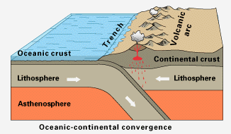
Off the coast of South America along the Peru-Chile trench, the oceanic Nazca Plate is pushing into and being subducted under the continental part of the South American Plate. In turn, the overriding South American Plate is being lifted up, creating the towering Andes mountains, the backbone of the continent. Strong, destructive earthquakes and the rapid uplift of mountain ranges are common in this region. Even though the Nazca Plate as a whole is sinking smoothly and continuously into the trench, the deepest part of the subducting plate breaks into smaller pieces that become locked in place for long periods of time before suddenly moving to generate large earthquakes. Such earthquakes are often accompanied by uplift of the land by as much as a few meters.
Oceanic-oceanic convergence
As with oceanic-continental convergence, when two oceanic plates converge, one is usually subducted under the other, and in the process a trench is formed. The Marianas Trench (paralleling the Mariana Islands), for example, marks where the fast-moving Pacific Plate converges against the slower moving Philippine Plate. The Challenger Deep, at the southern end of the Marianas Trench, plunges deeper into the Earth's interior (nearly 11,000 m) than Mount Everest, the world's tallest mountain, rises above sea level (about 8,854 m).
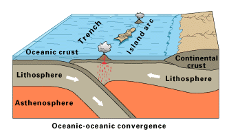
Subduction processes in oceanic-oceanic plate convergence also result in the formation of volcanoes. Over millions of years, the erupted lava and volcanic debris pile up on the ocean floor until a submarine volcano rises above sea level to form an island volcano. Such volcanoes are typically strung out in chains called island arcs. As the name implies, volcanic island arcs, which closely parallel the trenches, are generally curved. The trenches are the key to understanding how island arcs such as the Marianas and the Aleutian Islands have formed and why they experience numerous strong earthquakes. Magmas that form island arcs are produced by the partial melting of the descending plate and/or the overlying oceanic lithosphere. The descending plate also provides a source of stress as the two plates interact, leading to frequent moderate to strong earthquakes.
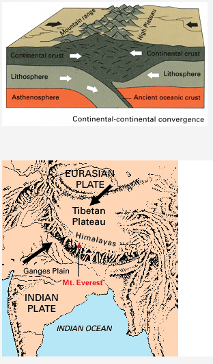
Continental-continental convergence
The Himalayan mountain range dramatically demonstrates one of the most visible and spectacular consequences of plate tectonics. When two continents meet head-on, neither is subducted because the continental rocks are relatively light and, like two colliding icebergs, resist downward motion. Instead, the crust tends to buckle and be pushed upward or sideways. The collision of India into Asia 50 million years ago caused the Indian and Eurasian Plates to crumple up along the collision zone. After the collision, the slow continuous convergence of these two plates over millions of years pushed up the Himalayas and the Tibetan Plateau to their present heights. Most of this growth occurred during the past 10 million years. The Himalayas, towering as high as 8,854 m above sea level, form the highest continental mountains in the world. Moreover, the neighboring Tibetan Plateau, at an average elevation of about 4,600 m, is higher than all the peaks in the Alps except for Mont Blanc and Monte Rosa, and is well above the summits of most mountains in the United States.
Transform boundaries
The zone between two plates sliding horizontally past one another is called a transform-fault boundary, or simply a transform boundary. The concept of transform faults originated with Canadian geophysicist J. Tuzo Wilson, who proposed that these large faults or fracture zones connect two spreading centers (divergent plate boundaries) or, less commonly, trenches (convergent plate boundaries). Most transform faults are found on the ocean floor. They commonly offset the active spreading ridges, producing zig-zag plate margins, and are generally defined by shallow earthquakes. However, a few occur on land, for example the San Andreas fault zone in California. This transform fault connects the East Pacific Rise, a divergent boundary to the south, with the South Gorda -- Juan de Fuca -- Explorer Ridge, another divergent boundary to the north.
The zone between two plates sliding horizontally past one another is called a transform-fault boundary, or simply a transform boundary. The concept of transform faults originated with Canadian geophysicist J. Tuzo Wilson, who proposed that these large faults or fracture zones connect two spreading centers (divergent plate boundaries) or, less commonly, trenches (convergent plate boundaries). Most transform faults are found on the ocean floor. They commonly offset the active spreading ridges, producing zig-zag plate margins, and are generally defined by shallow earthquakes. However, a few occur on land, for example the San Andreas fault zone in California. This transform fault connects the East Pacific Rise, a divergent boundary to the south, with the South Gorda -- Juan de Fuca -- Explorer Ridge, another divergent boundary to the north.
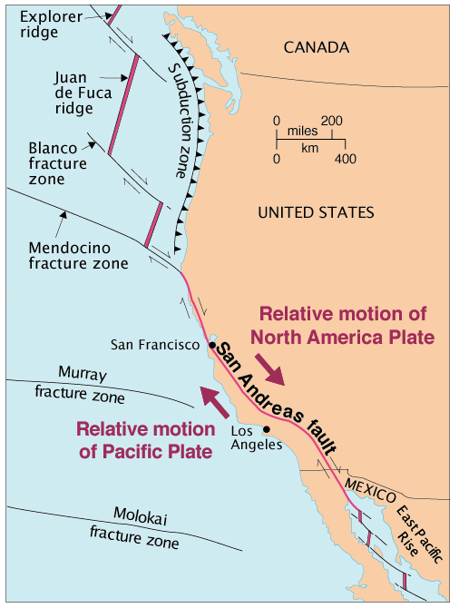
The San Andreas fault zone, which is about 1,300 km long and in places tens of kilometers wide, slices through two thirds of the length of California. Along it, the Pacific Plate has been grinding horizontally past the North American Plate for 10 million years, at an average rate of about 5 cm/yr. Land on the west side of the fault zone (on the Pacific Plate) is moving in a northwesterly direction relative to the land on the east side of the fault zone (on the North American Plate).
A wide variety of geographic formations are explained by from plate activity. The activity of the so-called "Ring of Fire," a famous group of extremely powerful volcanoes surrounding the Pacific Ocean, is caused by the movement of tectonic plates. The collusion of the Juan de Fuca and Gorda plates created the Cascade Mountain range and was responsible for the eruption of Mount St. Helens. The subduction of the Pacific plate under the Eurasian plate created the Japanese islands, and, in South America, the South American plate collided with the Nazca plate to create the Andes Mountains as well as both the Cotopaxi and Azul volcanoes.
Scientists have a fairly good understanding of the movements of plates and their interaction at plate boundaries, but there are still unanswered questions. While it is known that forces deep within the Earth's interior drive the motion of the plates, these forces are not yet well understood. And, while the plate tectonic theory helps to explain phenomenon such as volcanoes and earthquakes, it does not yet offer an explanation why the continents were originally joined or why they broke apart.
Questions
1. Describe the evidence used by scientists to support Wegener's theory of continental drift.
2. Describe the theory of seafloor spreading.
3. Describe the movement of the plates at a divergent boundary. Draw a diagram and give 2 examples of where this occurs.
4. Describe the movement of the plates at a convergent boundary. Draw a diagram and give 3 examples of where this occurs.
5. Describe the movement of the plates at a transform boundary. Draw a diagram and give 1 examples of where this occurs.
IN CLASS
