Day 5 - Due 11/7(A) 11/8(B) |
2.2 - Geologic History & Mapping |
The land that is North Carolina existed long before humans arrived --billions of years before, in fact. Based on the age of the oldest rocks found on earth as well as in meteorites, scientists believe that the earth was formed about 4,600 million years (4.6 billion years) ago. The landmass under North Carolina began to form about 1,700 million years ago, and has been in constant change ever since. Continents broke apart, merged, then drifted apart again. As landmasses came together, the Appalachian mountains (and other mountain ranges on the earth) were formed — and wind and water immediately began to wear them down by erosion. After North Carolina found its present place on the eastern coast of North America, the global climate warmed and cooled many times, melting and re-freezing the polar ice caps and causing the seas to rise and fell, covering and uncovering the Coastal Plain. Recent geologic processes formed the Sand Hills and the Outer Banks. The first humans arrived in North Carolina just 10,000 years ago — and continued the process of environmental change through hunting, agriculture, and eventually development.
- About 1700 million years ago, the land that would become North Carolina began to form
- About 1,300 million years ago, the first mountains were formed in North Carolina. Called the Grenville Mountains, they eroded long ago, but rocks formed at this time lie underneath the Appalachians and are exposed in parts of the Piedmont and Coastal Plain.
- The land under North Carolina was pulled apart, and inland seas emerged. Island volcanoes developed, first along the North Carolina-Virginia border, then in an arc from Virginia to Georgia. Rocks formed by those volcanoes extend today over a wide area of the Piedmont and Coastal Plain. Fossilized tracks of primitive worms have been found in those volcanic rocks, formed about 620 million years ago.
- By this time, the eastern coast of North America lay somewhere in middle Tennessee; except for islands and volcanoes, North Carolina was under water. About 750 million years ago, the landmasses of North America and Europe/Africa had begun moving towards each other again.
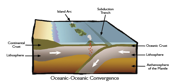
- A volcanic island arc was slowing traveling toward the Ancient North American coast. By 450 million years ago the island arc was in the process of slamming into (accreting with) ancient North America and forming the Uwharrie Mountains
- As the continents of North America and Europe/Africa moved together, more rock was pushed upwards, and over the next 100 million years, the Appalachian mountains were formed. As the Appalachians rose, streams carried sand and mud westward and filled the sea.
- About 320 million years ago, the North American and Euro-African continents collided, resulting in the last period of Appalachian mountain building. The land under the Piedmont and Coastal Plain was also pushed upward. The continents were united in a "supercontinent" that geologists call Pangaea.
- By 260 million years ago, the Appalachian mountains were complete. The resulting mountain range was 620 miles long, stretching from Canada, Great Britain, Greenland, and Scandinavia all the way south to Louisiana, and the mountains were as high as the highest mountains in the world today. Most likely, the tallest peaks were in what is now the eastern Piedmont and Coastal Plain.
- As soon as they had formed, the Appalachians began to erode. Wind and rain wore away the rock and carried it as sediment to lower-lying land or to the sea. Meanwhile, the continents began to move apart again.
- At this time, North Carolina probably lay near the equator, and had a tropical climate in which a great diversity of life must have flourished.
- As the North American continent drifted to the northwest, its trailing edge sank under water, and the Atlantic Ocean formed between North America and Africa. The shore was located near the present Outer Banks.
- The Appalachians continued to erode, leaving the flat land that now exists in the eastern Piedmont.
- 145 million years ago, the eastern portion of the modern Coastal Plain of North Carolina again lay under water, but the ocean receded late in this period. Elsewhere, the southern landmasses broke up, creating the continents of Africa and South America as well as the southern Atlantic Ocean. The youngest ranges of the Rocky Mountains formed.
- The crust under the Coastal Plain began to sink again, and the ocean pushed as far west as the modern Piedmont. The calcium-rich shells of microscopic algae sank to the ocean floor, where over time they became limestone. By the end the seas had again retreated.
- About 31 million years ago, the ocean advanced west as far as present-day New Bern.
- The land surfaces of the Blue Ridge and Piedmont now appeared essentially as they do today. A dry climate with short rainy seasons caused grasslands to flourish in the Piedmont. Shallow sea covered the eastern half of the Coastal Plain, then receded again.
- The Sand Hills formed during this time. Streams eroded the Piedmont and Blue Ridge, carrying sediment to the Coastal Plain. There, water seeped through those sediments, carrying heavier clay downward and leaving behind sands that were piled into dunes by winds.
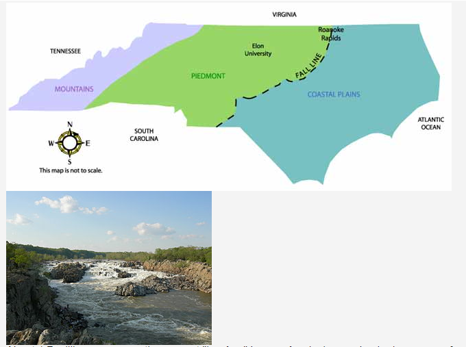
- The polar ice caps melted, and the sea level rose more than 300 feet above its present level. The resulting shoreline can be seen today in an escarpment — a sharp drop-off — that runs through Scotland, Hoke, and Cumberland counties. When the seas receded, that sudden change in elevation caused rivers to fall rapidly. The town of Cross Creek, which became Fayetteville, would be located along this "fall line."
- About 1.7 million years ago, the present "Ice Age" began. As glaciers and polar ice caps re-formed, sea level fell, exposing the Coastal Plain. Several periods of glaciation (the forming of glaciers) and melting followed, with corresponding falls and rises in sea level. A series of escarpments can now be seen at various points on the Coastal Plain where the shoreline once lay.
- The glaciers began to recede for the last time about 18,000 years ago. The rising seas left a ridge above water, creating the modern barrier islands.
- Between 10,000 and 15,000 years ago, as the climate warmed, North Carolina’s forests began to look as they do today, with pine, spruce, and fir in the cooler Blue Ridge and oak and hickory more common in the Piedmont.
- By 9,000 years ago, the climate stablized as the glaciers retreated, making agriculture possible. Human civilization emerged.
1. What was the first mountain range to form in NC? The 2nd? The 3rd? Which 2 still exist today?
2. How did the Uwharries form?
3. How did the Appalachians form?
4. What is the fall line? What caused it?
5. How and when did the barrier islands form?
