Day 4 - Due 11/5(A) 11/6(B) |
2.2 - Geologic History & Mapping |
AT HOME:
Introduction
Without being able to pinpoint a location, understanding Earth’s surface would be of little value. Scientists, and even people on the move, must have a system to locate themselves and important features on the Earth.
Location
Perhaps you are sitting in the front office at Clovis West High School in California (Figure below). There are many ways to indicate your location, any of which can be used to find you.
- Street address: 1070 East Teague, Fresno, California.
- Latitude and longitude: 36.85926°N, 119.76468°W.
- Triangulation: 168 miles from Santa Barbara, 122 miles from San Jose, and 24 miles from Auberry.
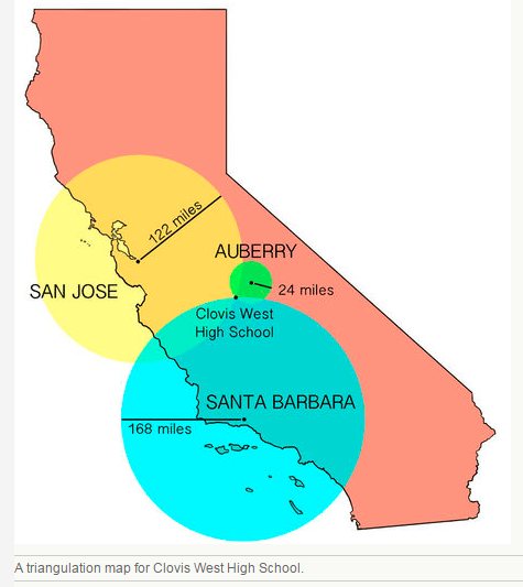
Any of these locations can be used and each has a different purpose. A postal worker might prefer to have a street address than to have to triangulate when delivering the mail. A geologist might want to know the latitude and longitude of an important feature. Triangulation is useful for locating where earthquakes and other things occur.
Direction
A line connecting two different locations has direction. Directions are expressed as north (N), east (E), south (S), and west (W) with gradations in between. Clovis West High School is north of Santa Barbara, east-southeast of San Jose, and southwest of Auberry. Direction is important for describing moving objects. For example, the wind may be blowing from southwest to northeast.
The most common way to describe direction in relation to the Earth’s surface is with a compass, a device with a floating needle that is actually a small magnet. The compass needle aligns itself with the Earth’s magnetic north pole, as demonstrated in the Figure below. A compass rose (Figure below) is a figure drawn on a map or nautical chart that shows directions or degrees.
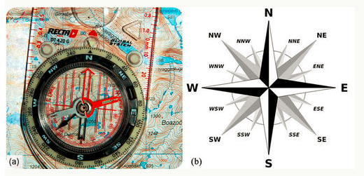
(a) A compass is used to determine direction. A compass overlaid on a map can be used to show the directions the features are from each other. (b) This compass rose shows the major directions at 90 degrees and divides them into halves at 45 degrees – northeast (NE), southeast (SE), southwest (SW), and northwest (NW) - and then divides them in half again at 22.5 degrees – NNE, ENE, ESE, SSE, SSW, WSW, WNW, and NNW. Sometimes a compass rose just shows degrees.
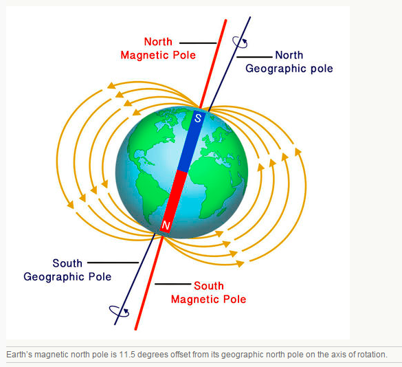
Earth’s magnetic north pole is different from its geographic North Pole, known as true north. The geographic North Pole is the point where the axis upon which Earth rotates intersects the planet’s surface in the north. To find directions on a map using a compass you must correct for this discrepancy. The Figure below illustrates this offset between geographic and magnetic north.
Earth’s magnetic north pole is different from its geographic North Pole, known as true north. The geographic North Pole is the point where the axis upon which Earth rotates intersects the planet’s surface in the north. To find directions on a map using a compass you must correct for this discrepancy. The Figure below illustrates this offset between geographic and magnetic north.
Latitude and Longitude
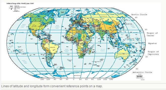
Any location on Earth’s surface -- or on a map -- can be described by latitude and longitude. Latitude and longitude are expressed as degrees that are divided into 60 minutes. Each minute is divided into 60 seconds.
Latitude tells the distance north or south of the equator. Latitude lines start at the equator and circle around the planet. The equator is the line that falls equally between the North and South Poles. The latitude of the equator is 0°. The North Pole is 90°N, with 90 degree lines in the Northern Hemisphere. The South Pole is 90°S, with 90 degree lines in the Southern Hemisphere (Figure below). The latitude of Clovis West High School (Figure above) is 36.85926°N expressed in degrees and fractions of degrees.
Longitude lines are circles that go around the Earth from north to south, like the sections of an orange. Longitude is measured perpendicular to the equator. The Prime Meridian is 0° longitude and passes through Greenwich, England. The International Date Line is the 180° meridian. The longitude of Clovis West High School is 119.76468°W expressed in degrees and fractions of degrees.
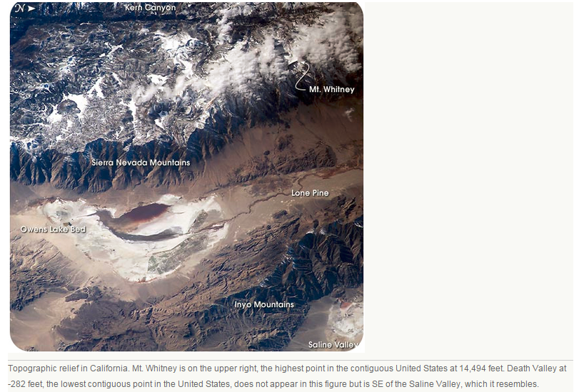
Since Earth is not flat, an accurate location must take into account the third dimension. Elevation is the height above or below sea level. Sea level is the average height of the ocean’s surface or the midpoint between high and low tide and is the same all around Earth. The topography of a region is the height or depth of that feature relative to sea level. Relief or terrain includes all the major features or landforms of a region. Figure below illustrates a topographic relief of California.
Questions
1. What are three ways to indicate a location?
2. When is triangulation useful?
3. What is the difference between the magnetic and geographic north pole? How does this affect determining location?
4. What does a topographic relief show us?
1. What are three ways to indicate a location?
2. When is triangulation useful?
3. What is the difference between the magnetic and geographic north pole? How does this affect determining location?
4. What does a topographic relief show us?
IN CLASS:
