Day 3 - Due 10/30(A) 11/4(B)2.2 - Geologic History & Mapping |
|
Introduction
Maps are extremely useful to Earth scientists to represent geographic features found above and below sea level and to show the geology of a region. Rock units and geologic structures are shown on geologic maps.
What is a Topographic Map?
Mapping is a crucial part of Earth science. Topographic maps represent the locations of geographical features, such as hills and valleys. Topographic maps use contour lines to show different elevations on a map. A contour line is a type of isoline; in this case, a line of equal elevation. If you walk along a contour line you will not go uphill or downhill. Mathematically, a contour line is a curve in two dimensions on which the value of a function f(x, y) is a constant.
Contour Lines and Intervals
Contour lines connect all the points on a map that have the same elevation and therefore reveal the location of hills, mountains, and valleys. While a road map shows where a road goes, a topographic map shows why. For example, the road bends in order to go around a hill or stops at the top of a mountain. On a contour map:
- Each contour line represents a specific elevation and connects all the points that are at the same elevation. Every fifth contour line is bolded and labeled with numerical elevations.
- The contour lines run next to each other and NEVER cross. After all, a single point can only have one elevation.
- Two contour lines next to one another are separated by a constant difference in elevation (such as 20 ft or 100 ft). This difference between contour lines is called the contour interval. The map legend gives the contour interval.
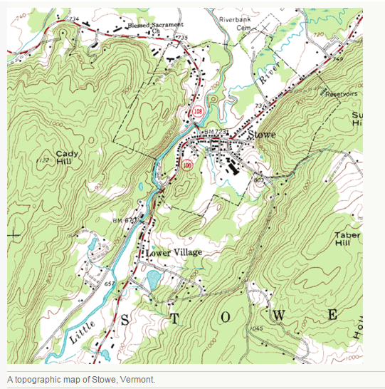
How would you calculate the contour interval on the map of Stowe, Vermont (see Figure above)?
- Calculate the difference in elevation between two bold lines.
- Divide that difference by the number of contour lines between them.
Interpreting Contour Maps
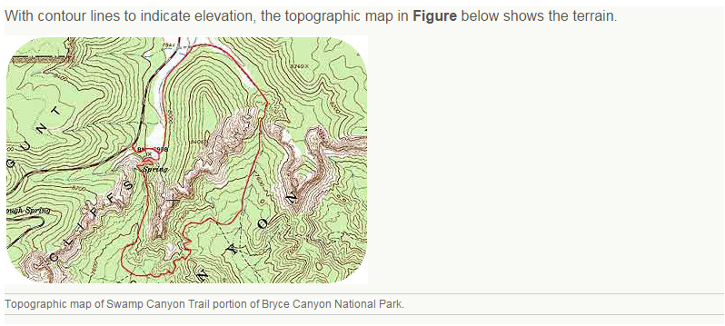
How does the map of Bryce Canyon reveal the terrain of the region? Several principles are important for reading a topographic map:
1. Contour lines show the 3-dimensional shape of the land (Figure below). What does the spacing of contour lines indicate?
How does the map of Bryce Canyon reveal the terrain of the region? Several principles are important for reading a topographic map:
1. Contour lines show the 3-dimensional shape of the land (Figure below). What does the spacing of contour lines indicate?
- Closely-spaced contour lines indicate a steep slope, because the elevation changes quickly in a small area.
- Contour lines that seem to touch indicate a very steep rise, like a cliff or canyon wall.
- Broadly spaced contour lines indicate a shallow slope.
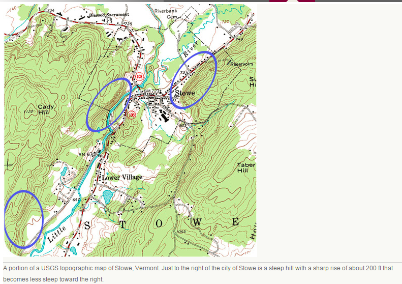
4. V-shaped expanses of contour lines indicate stream valleys. Where a stream crosses the land, the Vs in the contour lines point uphill. The channel of the stream passes through the point of the V and the open end of the V represents the downstream portion. If the stream contains water, the line will be blue; otherwise, the V patterns indicate the direction water will flow. In the map of Stowe, where does a stream run downhill into a lake?
Geologic Maps
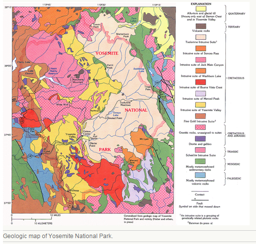
A geologic map shows the geological features of a region (see examples in the Figures below). Rock units are color-coded and identified in a key. In the map of Yosemite, volcanic rocks are brown, the Tuolumne Intrusive Suite is peach, and the metamorphosed sedimentary rocks are green. Structural features, such as folds and faults, are also shown on a geologic map. The area around Mt. Dana on the east central side of the map has fault lines.
- Start at the “T” in Stowe. A blue stream goes downhill (northwest) into a lake. Coming out of the T on the other side, you can follow the blue stream uphill (southeast). Where the water flow is light or nonexistent, there is no longer a blue line, but the contour lines point uphill indicating that the stream channel is still there (see the map of Stowe in Figure above).
- 1:24,000 scale – 1 inch = 2000 ft
- 1:100,000 scale – 1 inch = 1.6 miles
- 1:250,000 scale – 1 inch = 4 miles
Geologic Maps
A geologic map shows the geological features of a region (see examples in the Figures below). Rock units are color-coded and identified in a key. In the map of Yosemite, volcanic rocks are brown, the Tuolumne Intrusive Suite is peach, and the metamorphosed sedimentary rocks are green. Structural features, such as folds and faults, are also shown on a geologic map. The area around Mt. Dana on the east central side of the map has fault lines.
Lesson Summary
Questions:
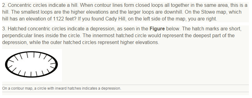
1. On a topographic map, contour lines create a group of concentric, closed loops. Which of the following features could this indicate?
a. a stream channel
b. a hilltop
c. depression
d. a cliff
2. Describe the pattern on a topographic map that would indicate a stream valley? how do you determine the direction of water flow?
3. On a topographic map, five countour lines are very close together in one area. The contour interval is 100 ft. What feature does that indicate? how high is this feature?
4. On a topographic map, describe how you can tell a steep slope from a shallow slope.
5. On a geologic map of the Grand Canyon, a rock unit called the Kaibab Limestone takes up the entire surface of the region. Down some steep topographic lines is a very thin rock unit called the Toroweap Formation and down more topographic lines into the canyon from that is another thin unit, the Coconino Sandstone. Describe how these three rock units sit relative to each other. Which is oldest and which is youngest?
- Topographic maps are 2-dimensional representations of the 3-dimensional surface features of an area.
- Topographic maps have contour lines that connect points of identical elevation above sea level.
- Contour lines run next to each other. Adjacent contour lines are separated by a constant difference in elevation, usually noted on the map.
- Topographic maps have a horizontal scale to indicate horizontal distances.
- People use topographic maps to locate surface features in a given area, to find their way through a particular area, and to determine the direction of water flow in a given area
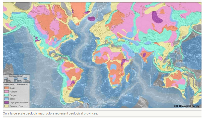
- Geologic maps display rock units and geologic features of a region of any size. A small scale map displays individual rock units; a large scale map shows geologic provinces.
Questions:
1. On a topographic map, contour lines create a group of concentric, closed loops. Which of the following features could this indicate?
a. a stream channel
b. a hilltop
c. depression
d. a cliff
2. Describe the pattern on a topographic map that would indicate a stream valley? how do you determine the direction of water flow?
3. On a topographic map, five countour lines are very close together in one area. The contour interval is 100 ft. What feature does that indicate? how high is this feature?
4. On a topographic map, describe how you can tell a steep slope from a shallow slope.
5. On a geologic map of the Grand Canyon, a rock unit called the Kaibab Limestone takes up the entire surface of the region. Down some steep topographic lines is a very thin rock unit called the Toroweap Formation and down more topographic lines into the canyon from that is another thin unit, the Coconino Sandstone. Describe how these three rock units sit relative to each other. Which is oldest and which is youngest?
