Day 3 due 11/20 (A) 11/21 (B)
Humidity
Humidity is the amount of water vapor in the air in a particular spot. We usually use the term to mean relative humidity, the percentage of water vapor a certain volume of air is holding relative to the maximum amount it can contain. If the humidity today is 80%, it means that the air contains 80% of the total amount of water it can hold at that temperature. What will happen if the humidity increases to more than 100%? The excess water condenses and forms precipitation.
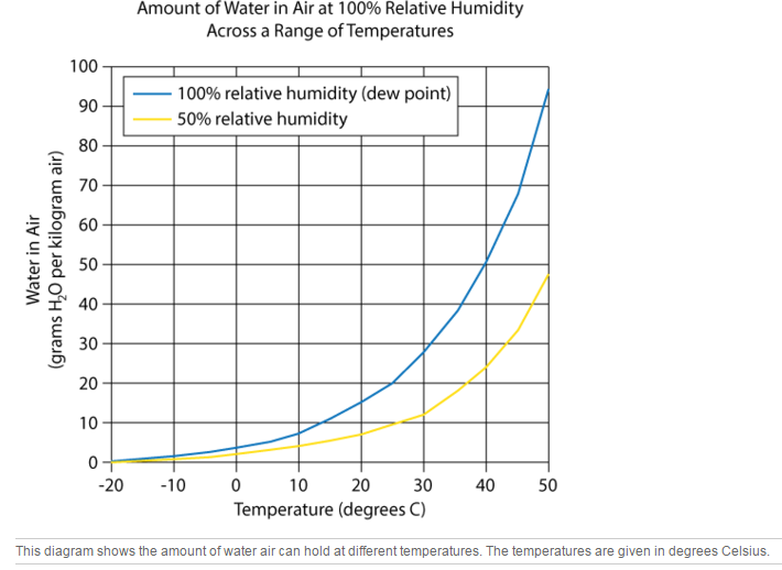
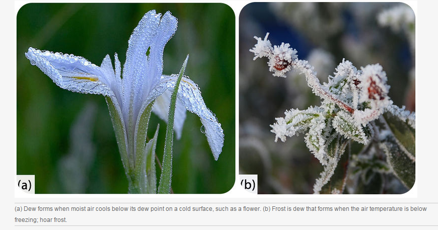
Since warm air can hold more water vapor than cool air, raising or lowering temperature can change air's relative humidity (Figure below). The temperature at which air becomes saturated with water is called the air's dew point. This term makes sense, because water condenses from the air as dew, if the air cools down overnight and reaches 100% humidity.
Humidity is the amount of water vapor in the air in a particular spot. We usually use the term to mean relative humidity, the percentage of water vapor a certain volume of air is holding relative to the maximum amount it can contain. If the humidity today is 80%, it means that the air contains 80% of the total amount of water it can hold at that temperature. What will happen if the humidity increases to more than 100%? The excess water condenses and forms precipitation.
Since warm air can hold more water vapor than cool air, raising or lowering temperature can change air's relative humidity (Figure below). The temperature at which air becomes saturated with water is called the air's dew point. This term makes sense, because water condenses from the air as dew, if the air cools down overnight and reaches 100% humidity.
Clouds
Clouds have a big influence on weather:
When there are no clouds, there is less insulation. As a result, cloudless days can be extremely hot, and cloudless nights can be very cold. For this reason, cloudy days tend to have a lower range of temperatures than clear days.
Clouds form when air reaches its dew point. This can happen in two ways: (1) Air temperature stays the same but humidity increases. This is common in locations that are warm and humid. (2) Humidity can remain the same, but temperature decreases. When the air cools enough to reach 100% humidity, water droplets form. Air cools when it comes into contact with a cold surface or when it rises.
Rising air creates clouds when it has been warmed at or near the ground level and then is pushed up over a mountain or mountain range or is thrust over a mass of cold, dense air.
Water vapor is not visible unless it condenses to become a cloud. Water vapor condenses around a nucleus, such as dust, smoke, or a salt crystal. This forms a tiny liquid droplet. Billions of these water droplets together make a cloud.
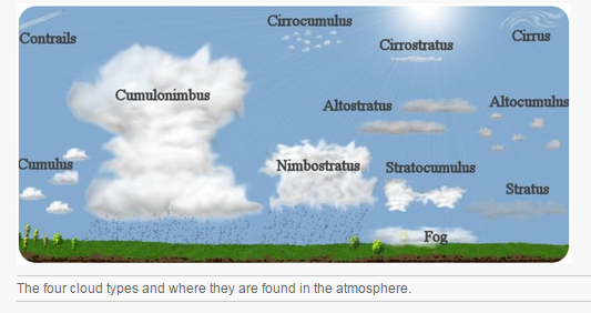
Clouds are classified in several ways. The most common classification used today divides clouds into four separate cloud groups, which are determined by their altitude (Figure below).
Clouds have a big influence on weather:
- by preventing solar radiation from reaching the ground.
- by absorbing warmth that is re-emitted from the ground.
- as the source of precipitation.
When there are no clouds, there is less insulation. As a result, cloudless days can be extremely hot, and cloudless nights can be very cold. For this reason, cloudy days tend to have a lower range of temperatures than clear days.
Clouds form when air reaches its dew point. This can happen in two ways: (1) Air temperature stays the same but humidity increases. This is common in locations that are warm and humid. (2) Humidity can remain the same, but temperature decreases. When the air cools enough to reach 100% humidity, water droplets form. Air cools when it comes into contact with a cold surface or when it rises.
Rising air creates clouds when it has been warmed at or near the ground level and then is pushed up over a mountain or mountain range or is thrust over a mass of cold, dense air.
Water vapor is not visible unless it condenses to become a cloud. Water vapor condenses around a nucleus, such as dust, smoke, or a salt crystal. This forms a tiny liquid droplet. Billions of these water droplets together make a cloud.
Clouds are classified in several ways. The most common classification used today divides clouds into four separate cloud groups, which are determined by their altitude (Figure below).
High Clouds
High clouds (Figure below) form from ice crystals where the air is extremely cold and can hold little water vapor. Cirrus, cirrostratus, and cirrocumulus are all names of high clouds.
High clouds (Figure below) form from ice crystals where the air is extremely cold and can hold little water vapor. Cirrus, cirrostratus, and cirrocumulus are all names of high clouds.
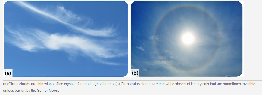
Cirrocumulus clouds are small, white puffs that ripple across the sky, often in rows. Cirrus clouds may indicate that a storm is coming.
Middle Clouds
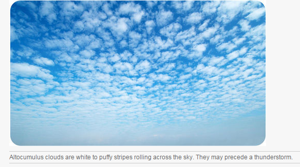
Middle clouds, including altocumulus and altostratus clouds, may be made of water droplets, ice crystals or both, depending on the air temperatures (Figure below).
Middle Clouds
Middle clouds, including altocumulus and altostratus clouds, may be made of water droplets, ice crystals or both, depending on the air temperatures (Figure below).
Thick and broad altostratus clouds are gray or blue-gray. They often cover the entire sky and usually mean a large storm, bearing a lot of precipitation, is coming.
Low Clouds
Low clouds (Figure below) are nearly all water droplets. Stratus, stratocumulus and nimbostratus clouds are common low clouds.
Low Clouds
Low clouds (Figure below) are nearly all water droplets. Stratus, stratocumulus and nimbostratus clouds are common low clouds.
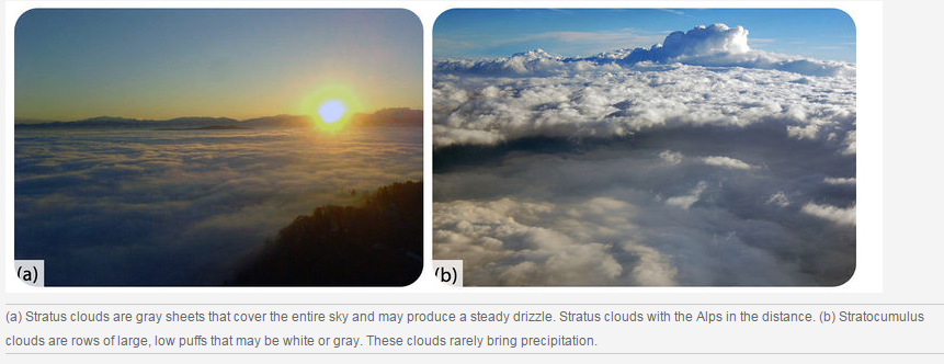
Nimbostratus clouds are thick and dark. They bring steady rain or snow.
Vertical Clouds
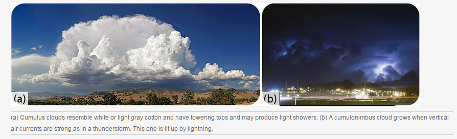
Clouds with the prefix 'cumulo-' (Figure below) grow vertically instead of horizontally and have their bases at low altitude and their tops at high or middle altitude. Clouds grow vertically when strong air currents are rising upward.
Vertical Clouds
Clouds with the prefix 'cumulo-' (Figure below) grow vertically instead of horizontally and have their bases at low altitude and their tops at high or middle altitude. Clouds grow vertically when strong air currents are rising upward.
Fog
Fog (Figure below) is a cloud located at or near the ground . When humid air near the ground cools below its dew point, fog is formed. The several types of fog that each form in a different way.
Fog (Figure below) is a cloud located at or near the ground . When humid air near the ground cools below its dew point, fog is formed. The several types of fog that each form in a different way.
- Radiation fog forms at night when skies are clear and the relative humidity is high. As the ground cools, the bottom layer of air cools below its dew point. Tule fog is an extreme form of radiation fog found in some regions.
- San Francisco, California, is famous for its summertime advection fog. Warm, moist Pacific Ocean air blows over the cold California current and cools below its dew point. Sea breezes bring the fog onshore.
- Steam fog appears in autumn when cool air moves over a warm lake. Water evaporates from the lake surface and condenses as it cools, appearing like steam.
- Warm humid air travels up a hillside and cools below its dew point to create upslope fog

Precipitation
Precipitation (Figure below) is an extremely important part of weather. Some precipitation forms in place .
Precipitation (Figure below) is an extremely important part of weather. Some precipitation forms in place .
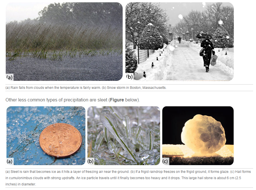
The most common precipitation comes from clouds. Rain or snow droplets grow as they ride air currents in a cloud and collect other droplets (Figure below). They fall when they become heavy enough to escape from the rising air currents that hold them up in the cloud. One million cloud droplets will combine to make only one rain drop ! If temperatures are cold, the droplet will hit the ground as a snowflake.
Questions:
1. What happens when a batch of air reaches its dew point? What is the temperature?
2. What effect do clouds have on weather?
3. You are standing in a location that is clear in the morning, but in the afternoon there are thunderstorms. There is no wind during the day, so the thunderstorms build directly above you. Describe how this happens.
4. What are the four different cloud groups and how are they classified?
5. How does sleet form? How does glaze form?
6. What circumstances must be present for enormous balls of hail to grow and then fall to the ground?
